Educational note: This site publishes independent educational content for general readers. Articles about ecology, wildlife, conservation, pollution, animal behavior, or environmental risk are informational only and should not be treated as scientific, legal, regulatory, veterinary, medical, emergency, or professional advice. Consult qualified experts, peer-reviewed sources, and official local guidance before making decisions.
The Earth’s oceans are not merely vast bodies of water; they are the lifeblood of our planet, driving climate patterns, hosting diverse ecosystems, and concealing geological wonders that remain largely unexplored. Understanding the ocean requires a multi-dimensional approach that spans from the microscopic salinity of a single drop of water to the massive, planet-spanning “conveyor belts” known as ocean currents. This guide provides an in-depth analysis of the mechanisms that govern our seas, the technology we use to monitor them, and the natural mysteries that continue to captivate the scientific community.
The Power and Influence of Ocean Currents on Global Climate
Ocean currents are continuous, directed movements of seawater generated by forces such as breaking waves, wind, the Coriolis effect, temperature, and salinity differences. These currents act as a global thermostat, redistributing heat from the equator to the poles and significantly influencing regional climates. Without these systems, the Earth’s temperature extremes would be far more severe, making much of the planet uninhabitable.
The Gulf Stream and the North Atlantic Drift
One of the most well-known and influential current systems is the Gulf Stream. Originating in the Gulf of Mexico and flowing along the eastern coast of the United States before crossing the Atlantic, this warm current carries more water than all the world’s rivers combined. As it reaches Western Europe, it transforms into the North Atlantic Drift, bringing mild temperatures to regions like the United Kingdom and Norway, which would otherwise experience much harsher, sub-arctic winters.
Thermohaline Circulation: The Global Conveyor Belt
Beyond surface currents, there exists a deep-water movement known as Thermohaline Circulation. This “global conveyor belt” is driven by density gradients. Cold, salty water is denser and sinks in the North Atlantic, flowing southward along the ocean floor, while warmer surface waters move to replace it. This process takes approximately 1,000 years to complete a single cycle and is a critical component of the Earth’s carbon cycle, as it transports dissolved CO2 into the deep ocean.
- Surface Currents: Driven primarily by wind patterns and the Earth’s rotation (Coriolis effect).
- Deep Currents: Driven by differences in water density (temperature and salinity).
- Upwelling: Occurs when deep, nutrient-rich water rises to the surface, supporting massive blooms of phytoplankton and rich fishing grounds.

The Chemical Blueprint: Understanding Ocean Salinity and Composition
Ocean salinity refers to the concentration of dissolved salts in seawater. While the average salinity of the global ocean is approximately 35 parts per thousand (ppt), this figure varies significantly depending on geographical location, evaporation rates, and freshwater input. Salinity is a fundamental driver of ocean density and, consequently, the circulation patterns mentioned above.
Sources of Ocean Salt
The primary source of ocean salt is the weathering of rocks on land. Rainwater, which is slightly acidic, breaks down minerals and carries ions like sodium and chloride into rivers, which eventually deposit them into the sea. Additionally, hydrothermal vents on the ocean floor contribute significant amounts of dissolved minerals, including magnesium and calcium, directly from the Earth’s crust.
Regional Variations in Salinity
Salinity is not uniform across the globe. Factors that increase salinity include high evaporation rates and the formation of sea ice (which leaves salt behind). Conversely, factors that decrease salinity include heavy rainfall, melting ice, and large river discharges. Below is a comparison of salinity levels in different marine environments:
| Region | Average Salinity (ppt) | Primary Influence |
|---|---|---|
| Red Sea | 40+ ppt | High evaporation, low rainfall |
| Dead Sea | 300+ ppt | Landlocked, extreme evaporation |
| Baltic Sea | 7-15 ppt | High freshwater input from rivers |
| Open Ocean | 34-37 ppt | Standard global equilibrium |

Architects of the Abyss: Undersea Volcanoes and the Birth of New Land
Undersea volcanoes, or submarine volcanoes, are vents or fissures in the Earth’s surface from which magma can erupt. They are most commonly found near areas of tectonic plate movement, specifically mid-ocean ridges and subduction zones. While many remain hidden beneath the waves, their activity is responsible for the creation of new seafloor and, occasionally, the birth of entirely new islands.
The Process of Island Formation
When an undersea volcano erupts, the lava cools rapidly upon contact with the cold seawater, forming solid rock. Over thousands or millions of years, repeated eruptions build the volcanic structure higher until it breaches the surface. Famous examples include the Hawaiian Islands and the island of Surtsey off the coast of Iceland, which was formed in 1963. These new landmasses provide unique opportunities for scientists to study primary succession—how life colonizes brand-new, sterile environments.
Hydrothermal Vents and Extremophiles
Volcanic activity also creates hydrothermal vents, which act as underwater geysers. These vents spew mineral-rich, superheated water into the ocean. Remarkably, these environments host complex ecosystems that do not rely on sunlight for energy. Instead, bacteria use a process called chemosynthesis to convert chemicals like hydrogen sulfide into energy, supporting a food web of giant tube worms, blind shrimp, and unique crab species.

The Interface of Two Worlds: Ecology of the Magical Intertidal Zone
The intertidal zone, also known as the littoral zone, is the area where the ocean meets the land between high and low tides. This environment is one of the most challenging on Earth, as organisms must adapt to being submerged in saltwater and exposed to the air and sun within the same day. This constant flux creates distinct “zones” of life based on the duration of exposure.
Zonation and Biological Adaptations
The intertidal zone is typically divided into the high-tide zone, middle-tide zone, and low-tide zone. In the high-tide zone, organisms like barnacles and limpets have developed hard shells to prevent desiccation (drying out) and strong adhesives to withstand the crashing waves. In the low-tide zone, which is submerged most of the time, biodiversity increases significantly, featuring sea anemones, sea stars, and various seaweed species that require more consistent water coverage.
- Environmental Stressors: Temperature fluctuations, salinity changes (due to rain or evaporation), and physical wave action.
- Ecological Role: These zones act as nurseries for many marine species and provide critical feeding grounds for migratory birds.

Monitoring the Deep: Seafloor Seismic Networks and Planetary Safety
As human populations grow along coastlines, the need for advanced warning systems for geological hazards has become paramount. Seafloor Seismic Observation Networks are sophisticated arrays of sensors placed on the ocean floor to monitor crustal movements, earthquake activity, and the potential for tsunamis. Unlike land-based stations, these networks provide real-time data from the very sources of seismic activity.
Infrastructure and Technology
Modern seafloor networks utilize thousands of kilometers of fiber-optic cables to transmit data at high speeds to terrestrial research centers. These cables power a variety of instruments, including seismometers, pressure sensors (to detect tsunami waves), and hydrophones. Projects like the DONET in Japan and Ocean Networks Canada are leading the way in providing early warnings that can save lives by giving coastal residents precious minutes to evacuate before a tsunami hits.
Future Trends in Marine Observation
The future of seafloor monitoring lies in the integration of Artificial Intelligence (AI) and autonomous underwater vehicles (AUVs). AI can analyze seismic patterns to predict eruptions or quakes with higher accuracy, while AUVs can be deployed to maintain sensors or explore areas too dangerous for human-operated equipment. This infrastructure is also being used to study the impact of climate change on the deep ocean, such as changes in water temperature and acidity.

Unraveling Anomalies: Natural Mechanisms Behind the Bermuda Triangle
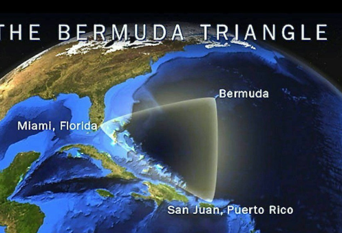
The Bermuda Triangle, a region in the western part of the North Atlantic Ocean, has long been the subject of myth and legend due to the alleged disappearance of ships and aircraft. However, scientific investigation suggests that these “mysteries” can be explained by a combination of natural environmental factors unique to the region.
Magnetic Declination and Compass Errors
The Bermuda Triangle is one of the few places on Earth where true north and magnetic north align. This phenomenon, known as magnetic declination, can cause compasses to give readings that appear “off” to inexperienced navigators. If a pilot or captain does not account for this variation, they can easily drift off course into the vast, open ocean.
Methane Hydrates and Rogue Waves
Geological surveys have revealed large deposits of methane hydrates trapped beneath the seafloor in this region. If these deposits are disturbed by seismic activity, they can release massive bubbles of gas. These bubbles significantly reduce the density of the water, potentially causing a ship to lose buoyancy and sink rapidly. Furthermore, the convergence of multiple current systems, including the Gulf Stream, can create “rogue waves”—massive, unpredictable walls of water that can reach heights of over 100 feet, capable of overwhelming even the largest vessels.
Frequently Asked Questions (FAQ)
- Q1: Why is the ocean salty but rivers are fresh?
- Rivers carry very low concentrations of dissolved salts from land. Because the ocean has no outlet other than evaporation, these salts accumulate over millions of years. Evaporation removes pure water, leaving the minerals behind, which concentrates the saltiness over time.
- Q2: How do undersea volcanoes affect the temperature of the ocean?
- While undersea volcanoes release immense heat locally, the sheer volume of the ocean means they do not significantly change global water temperatures. However, they do create localized “hotspots” and hydrothermal vent systems that are vital for specific deep-sea ecosystems.
- Q3: Can ocean currents really stop?
- While it is unlikely they would stop entirely, scientists are concerned that melting glaciers (freshwater) could disrupt the “Global Conveyor Belt” by making the water in the North Atlantic less dense, preventing it from sinking. This could lead to dramatic climate shifts in Europe and North America.
- Q4: Are seafloor seismic networks expensive to maintain?
- Yes, they are incredibly expensive due to the harsh conditions of the deep sea, which cause corrosion and pressure damage. However, the cost is outweighed by the billions of dollars in property damage and thousands of lives saved through early tsunami warnings.
- Q5: What is the most dangerous part of the intertidal zone?
- For humans, the physical force of the waves and the slippery, uneven terrain are the primary dangers. For marine life, the “high-tide zone” is the most dangerous due to the risk of desiccation and extreme temperature changes when the tide is out.